 |
|
|
IBRI Research Report #16 (1983)
CORAL REEFS & RELATED CARBONATE STRUCTURES
AS INDICATORS OF GREAT AGE
Daniel E. Wonderly
4064 Pleasant Valley
Oakland, MD 21550
Copyright © 1983 by Daniel E. Wonderly. All
rights
reserved.
EDITOR'S NOTE
| Although the author is in agreement with the doctrinal statement of IBRI, it does not follow that all of the viewpoints espoused in this paper represent official positions of IBRI. Since one of the purposes of the IBRI report series is to serve as a preprint forum, it is possible that the author has revised some aspects of this work since it was first written. |
ISBN 0-944788-16-5
Non-radiometric evidences for long periods of time in earth's history which do not however indicate an evolutionary origin for life on the earth are abundant. Data concerning these evidences are available in the literature of petroleum geology and in other geologic reports, but these have been overlooked or disregarded by the recent creationist movement. Many large, biologically-built, in situ structures are found within limestone and dolostone formations throughout the world. The growth, burial and carbonate cementation of these indicate the passage of a significant number of years for each layer. It is considered important and proper that we regard the natural laws which govern biological growth and growth rates to have been essentially constant ever since the creation of life on earth. Evidences for accepting these laws as stable are numerous.
Modern coral atolls in the Pacific give every evidence of having been formed by the natural growth of corals and lime-secreting algae. Eniwetok Atoll is a "cap" of approximately 4,600 feet of coral-algal reef material, resting on an extinct volcanic cone which rises two miles above the ocean floor. The fastest known growth rate of 8 mm per year for such reefs can not be simply applied to this thickness because periods of growth stoppage and weathering are revealed at several levels in the drilling cores.
Ancient, buried coral reefs exist in some of the oil fields of Alberta, Canada. Some of these closely resemble the form of living atolls of the Great Barrier Reef, with many kinds of identifiable fossils in them. Some of these ancient atolls rise to a height of 800 feet above the foundation sediments upon which they rest. Both the foundation sediments and the layers which later buried the reef indicate the passing of long periods of time because of the evaporitic nature of the layers. Above these layers are more than 4,000 feet of sedimentary rock strata, much of which is limestone of types which could not have been formed rapidly.
The Great Bahama Bank is a very large structure, composed entirely of carbonate sediments, most of which were produced by biological processes. It rises abruptly from the sea floor to a thickness of more than 17,000 feet. Additionally, drillings made within the past three years indicate that carbonate sedimentologists have been correct in taking this bank to have formerly been an active coral atoll. All across the present surface of the atoll we can readily observe the continuing processes of carbonate sediment production by many kinds of lime-secreting organisms. These and the process of oöid formation have added approximately 35 meters of sediment since the time that coral growth became drastically reduced. The present rate of this addition is approximately 30 centimeters per thousand years.
Fossilized hardgrounds and stromatolites, resulting from biological growth, exist at many stratigraphic levels in most parts of the world. The types of organisms which encrusted the upper surfaces of the hardground layers and formed the stromatolites are usually well known. Vertically repeating sequences of these hardground and stromatolite layers exist at many locations.
Introduction
One of the most important -- if not the most important -- evidences for long periods of time in Earth's history is the presence of large calcium carbonate structures in the oceans and within the sedimentary formations of the earth, which were built up by living organisms. A very large number of marine animals and plants secrete skeletal materials for the protection and/or stability of their soft, cellular parts. The calcium carbonate which they secrete must first be extracted from the sea water by the complex metabolic processes of the secreting cells. It is universally recognized by both Christian and non-Christian scholars that the life processes (cell metabolism, digestion, excretion, secretion, etc.) of living organisms have remained essentially constant since the origin of these organisms.
Our grounds for being confident that the metabolic processes have remained relatively constant include (a) the fundamental stability of the physical laws by which metabolism is made possible (diffusion, chemical reactions, colloidal relationships, etc.), (b) the structure of individual fossils, (c) the form and organization of fossilized communities of ancient organisms, and (d) the fact that there has evidently been no great or fundamental change in metabolic processes since the time of the Garden of Eden (the Bible represents life in the Garden as similar to that which we have today).
The relative constancy of the metabolic processes during the time which has elapsed since the creation of life leaves us with a firm basis on which to discuss the amounts of time represented by the great geologic structures which were formed as a result of biological growth. As we progress into the body of this paper, it will be seen that long spans of time are also demonstrated not only by the growth of lime-secreting organisms, but also by other fundamental parts of the sedimentary rock-forming process which are not dependent upon growth rates. These include the cementation of the grains which make up carbonate rocks and the processes by which layers of evaporite minerals are laid down from evaporating sea water.
A careful treatment of carbonate structures and of the other sedimentary deposits associated with them is especially important because of the fact that they have been completely overlooked by at least most of the leaders in the fundamentalist creationist organizations which have developed with the past 15 years. Most of the data which are given in the following parts of this paper have been well known and much used by the scientific world for more than a decade, but because this information was available mainly in the technical journals, the creationist leaders did not become familiar with it. Instead, they have usually continued to suppose that the great limestone formations of the world were merely the result of physical processes such as abrasion, precipitation, water transport, settling, and some unknown rapid process of hardening. Thus they failed to realize that great, biologically-built carbonate structures exist, and that (a) most of the carbonate sediments which are a part of these structures consist of grains which were produced near the site of their final deposition and cementation, and (b) that these grains were finally cemented into limestone with crystals of calcium carbonate carried by slowly percolating water, before the often-enormous weight of strata above were added.
Modern Coral Atolls in the Pacific
In the Pacific Ocean a number of very thick coral atolls grow on extinct volcanic cones (seamounts). These have left us a record of their growth through long periods of time. The most useful of these atolls for time calculations is the Eniwetok Atoll in the Marshall Islands. This structure was thoroughly studied by deep core drillings and other studies from 1946 through 1952, before the atomic bomb tests were carried out on it. The Eniwetok Atoll was found to be a living, active reef which exhibits the active processes of dissolution, cement precipitation, and other phases of fossilization just beneath the living growth layer which appears at the surface (Schlanger, 1963).
The Eniwetok Atoll rests on a roughly-circular, extinct volcanic cone which rises to approximately two miles above the surrounding ocean floor. The reef cap resting on this seamount is nearly one mile thick. The deepest drill hole put down by the U. S. Geological Survey penetrated 4,610 feet of coral-algal reef material before striking the basalt of the volcanic base. This drilling not only encountered the expected reef materials and cemented limestone layers, but also penetrated three very definite, extensively-weathered unconformity levels, at depths of 300 ft., 1,000 ft., and 2,780 ft. respectively. The limestone just beneath these unconformities shows not only the marks of weathering, but also the kind of calcite cementation which typically occurs when limestone lies for many years above the salt water level, exposed to fresh water from rains. Further evidence of the length and extent of these unconformities is found in the presence of large amounts of pollen from seed-bearing trees and shrubs which grew on the reef during the periods of exposure (Leopold, 1969, pp. 1138, 1145-59).
The organically-produced components retrieved by the Eniwetok drilling project, together with descriptions of the unconformities, are listed in extensive detail in Ladd (1960), which is readily available in most university libraries. A considerable amount of this material has also been summarized in Wonderly (1977, pp. 23-47).
The exact length of time required for the growth and formation of the Eniwetok reef is, of course, unknown. The U. S. Geological Survey team which did the research on it made estimates of the age of the various stratigraphic levels which they encountered in drilling. These estimates were based on traditional methods of fossil dating and on radiometric calculations. The oldest level of the reef was dated as Eocene but, for the purposes of this paper, we prefer to think in terms of how much time would be required, at the fastest known growth rates for reefs in the Pacific, to produce the amount of sediment which is contained in the Eniwetok Atoll. This amount of time is of course far less than the actual formation time, because one must allow for the periods of no growth (unconformities) mentioned above. These were periods when the top of the atoll "stood hundreds of feet above the sea. Eniwetok Atoll was a high island, and bore a high-island fauna and flora, not once but several times" (Ladd, 1961, p. 711). We must add to these long periods of exposure and erosion the various shorter periods of growth retardation or stoppage due to the development of unfavorable environmental conditions as explained in Wonderly (1977, pp. 25-32).
During the past 75 years several research projects have been carried out for actually measuring the rates of growth of living reefs in tropical and sub-tropical waters. Probably the most elaborate and extensive of these projects was that of A. G. Mayor and his team of scientists and assistants. This was a four-year Carnegie expedition to the Samoan Islands in which Mayor and his associates repeatedly observed and recorded the new reef growth being formed on a measured 2,550,000 square-foot reef flat between Breaker Point and Pago Pago Harbor. The final result of these extended observations, collections and weight measurements was the conclusion that approximately 8 millimeters of calcium carbonate mineral were being added to the reef flat per year. However, Mayor called attention to the fact that this could not result in a permanent increase of 8 mm per year in the thickness of the reef unless the sea level were rising (or the reef foundation sinking) that much each year. Otherwise most of the added material is pulverized, some to be dissolved, and some to be carried outward to broaden the edges of the reef (Mayor, 1924).
This work of Mayor and his associates is, so far as we know, the most thorough determination of reef growth that has been made in a geographic area of optimum reef-growing conditions. The result were similar to those found in the growth-rate research of Hoffmeister (1964) and Vaughn (1915).
In the Marshall Islands, growth rate estimates were made at the surface of the Rongelap Atoll, which is approximately 300 miles east of Eniwetok. The method used was not a thorough, direct measurement such as Mayor used in the Samoan Islands, but was based on a careful measurement of the amount of oxygen consumed by the entire living population per square meter, per hour. The measurement was made during the night, when the lime-secreting algae would have to use oxygen, just as the corals do. The theoretical depositions rate obtained was 14 mm of calcium carbonate per year, but the research team was quick to point out that this was much more than the actual rate, because many of the organisms living on the reef do not deposit lime, and some of them have respiration rates much higher than do the corals and lime-secreting algae (the two main kinds of lime-secreting organisms). Then a further limit on the rate of actual reef growth would be that concerning the rate of sea level change mentioned above, at the end of Mayor's work. When the research team in the Marshall Islands applied another method, viz., that of estimating the rate of growth since the first terrace down from the rim of the atoll was built, they arrived at a figure of only 0.91 mm per year. This was found to be approximately the same for Rongelap, Bikini, and Eniwetok Atolls (Emery, 1954, pp. 140-41). However, since the 1940s, when these calculations were made, it has been learned that the dates of the last ice age (and the succeeding rise in sea level) were more recent than was thought at that time. Thus we could safely convert their estimate to 1.8 mm per year.
If we apply the fastest growth rate of Mayor's research (8 mm per year) to the total thickness of the Eniwetok Atoll, we obtain 176,000 years. Using Mayor's rate here may be permissible, since the Samoan Islands have a temperature and latitude similar to that of the Marshalls, but we must remember that Mayor's rate was only for the ideal conditions in which the sea level is rising at the same rate as reef growth a condition which neither he nor we would dare assume for the entire life of the reef. Then too, we must make allowance for the long intervals of exposure and erosion of the Eniwetok Atoll, placing its origin much further back in time than any simple application of the growth rates would yield.
Within the last ten years very reliable methods for chemically deriving maximum calcium carbonate production rates of reefs have been developed. These are based on the amount of calcium in the water, and on the controlling factors such as temperature and rate of movement of the water across the reef. An article by S. V. Smith and D. W. Kinsey (1976) gives an excellent summary of these chemical methods of growth rate estimation, the results obtained, and how they compare with the earlier biological estimates. In several extensive series of chemical tests, including new tests made in the Marshall Islands, 5 mm of upward growth per year was found to be the maximum possible with the present Ca+2 and CO3-2 content of sea water. It is, of course, possible that the ion concentrations of sea water were once significantly different from those at present but, when we take into account the necessity of reasonably constant kinds of environment for the animals and plants of the world, we cannot postulate enormously greater growth rates than the maximum ones found on the earth at the present time.
Ancient Buried Coral Reefs in Canada
There are many coral and coral-algal reefs which long ago ceased to be living reefs, and have been buried under a thick series of various kinds of sediments. Some of the best known of these are in the oil fields of Alberta, Canada. Since the ancient reefs are highly porous they serve as important oil reservoirs in many parts of the world, and the oil drilling records give us extensive data on the nature of the reefs.
In the "Rainbow area" of northwestern Alberta there are a number of true coral reefs found at a depth of between 5,000 and 6,000 feet below the land surface in Middle Devonian, marine strata. These reefs apparently developed under favorable conditions, as many of them grew in the familiar forms (shapes) seen in the thriving Great Barrier Reef area of Australia (Barss, 1970, pp. 34-35). In fact, some of the atolls still retain the clear distinction between what was the more vigorously-growing side (facing the flow of water brought by the prevailing winds) and the less rapidly-growing side (Barss, 1970, p. 34). This corresponds to the growth of living atolls in the Pacific, where the lime-secreting organisms on the windward side respond to the inflow of water which is laden with a fresh supply of oxygen and food.
The organisms which produced these Canadian reefs were typical marine animals and calcareous algae. The fossils of these are abundant in the bodies of the reefs, and numerous places in the reefs have the fossils still in undisturbed position. J. R. Langton and his associates made a detailed study of drilling cores from forty-five wells which had been drilled into these reefs in the Rainbow area. They carefully examined 15,000 linear feet of well-core slabs under low-power microscopes, and studied some of the sediments under higher powers. In this study they were able to identify scores of kinds of fossils, and also to note which cores contained types of fossils which normally grow in the forereef, the lagoon, and the basins beside reefs, respectively. Numerous parts of the reefs were found to be still intact, having been built by wave-resistant organisms, including both colonial ceptate corals, and the extinct tabulate corals (Langton, 1968, pp. 1933-43).
Several of the reefs of the Rainbow area have relatively steep sides, arising sharply above the floor of the earlier "foundation sediments." Some rise to a height of approximately 800 feet (Langton, 1968, pp. 1930-42). The different forms (shapes) of these structures are significant as evidence of their similarity to modern reefs. In order to determine the forms, Langton and his associates combined the results of extensive seismic (earth-shock) studies of the area which had previously been made, with their own investigations of the well cores and drilling records. (The wells cores are, of course, carefully cataloged as to the exact position and depth from which each was taken from the well.) As a result of this study the team was able to classify the reefs into four types, namely, "large atoll," "crescent atoll," "small pinnacle" and "large pinnacle." The term "pinnacle" is perhaps somewhat misleading, as the sides are not nearly so steep as what we usually think of as a pinnacle. Their name is derived from the fact that they are in the shape of a practically symmetric cone with a circular base, tapering toward the top. Since they do arise to nearly 800 feet above the surrounding sediment layers, the name is perhaps permissible. These could not properly be called atolls as they have no lagoon in the center. With a diameter of often less than 2,000 feet near the top, there was not room for a lagoon to form there.
The fact that the pinnacle and atoll reefs grew in a normal marine environment, and were not disturbed by unusual catastrophic conditions is indicated not only by their normal, reef-like form, but also by the distribution of the fragments which lie around them. The deposits of fragments which wore off the reefs (often called "reef debris") during the time they were growing are found near the bases of the reefs, not scattered widely over the bottom of the basin. This shows that each reef grew as a distinct entity and retained its position and shape until it was later covered over and became an oil reservoir (Barss, 1970, p. 35).
Perhaps of the greatest interest are the large atoll and crescent atoll types, which resemble some of their modern counterparts north of Australia, as mentioned above. One typical large atoll of the Rainbow oil-bearing strata is four miles long and two and one-half miles wide. A lagoon, with typical fine-grained, lagoonal-type reef sediments, is present in the center. The total vertical thickness of this atoll at its rim is 800 feet, which indicates that many thousands of years were required for its development.
We must now briefly describe the main types of sediment layers which lie beneath and above the reefs of the Rainbow area of Alberta. A very high proportion of these strata are of types which can be laid down only very slowly by marine waters, and during a number of distinct and differing environmental conditions.
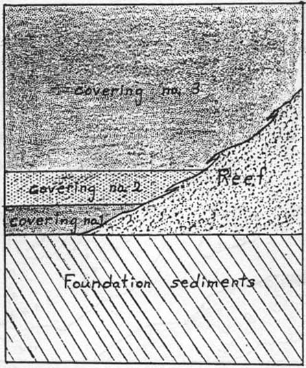
The total thickness of the sediments which lie beneath the reefs of the Rainbow area (designated "foundation sediments" in Figure 1) ranges from about 600 feet in some places to less than 100 feet in others. Some parts of this deposit contain an abundance of marine fossils. The arrangement and nature of these foundation sediments give unmistakable evidence that they represent a long period when a shallow sea covered the area. The entire 600-foot thick series consists of many alternating layers of shale, siltstone, anhydrite (calcium sulfate), limestone, and dolomite (Barss, 1970, pp. 23-25). All of these, except perhaps the siltstone, represent kinds of sediments which require a considerable period of time for the laying down of even a thin layer. In the lower two-thirds of the series, fossils are not abundant, giving further evidence that these layers were formed slowly in a sea that was so quiet that most of the fossil shells were either dissolved or broken into fine grains before being covered over.
A very meaningful part of this particular time record is the set of layers of evaporite material (in this case anhydrite, as mentioned above). They are found interspersed between the layers of shale, silt and dolomite at various points in the local stratigraphic column. These evaporite layers are of much the same types as those which are presently being deposited in the shallow, brinish waters in some parts of the Persian gulf, the Caspian Sea, and on the coast of Baja California, south of San Diego. Therefore, we can only conclude that they were formed in relatively shallow, evaporative basins of the ancient inland sea. Each recurring evaporite layer of anhydrite which appears in the well cores, as one progresses up the stratigraphic column in that geographical area, undoubtedly represents a period of time when the amount of water flowing into this inland sea was restricted (as is also true in modern evaporite-forming seas).
The amount of time represented by the sediment layers which cover the reefs of the Rainbow area is even more impressive than that of the layers beneath. The Canadian oil drillers in these oil fields find more than 4,000 feet of shale, sandstone, siltstone, chert, limestone, and dolostone lying above the reefs. These are in varying multi-layered formations, most of which are of types which could not have been laid down by rapidly moving water (Table 1). The limestone and dolostone make up between 1,000 and 2,000 feet of this covering. Practically all of the layers of limestone and dolostone are of types which could have been formed only by the usual slow processes of limestone formation.
But even more impressive than all of this 4,000 feet is the set of layers which immediately surround and cover the reefs. The latter are known collectively as the Muskeg Formation, and are classified as Middle Devonian. This formation which covers the Rainbow reefs is made up primarily of evaporite minerals. The evaporite layers give testimony to the condition of stagnation and increased salinity of the water. The fact that the larger reefs became heavily dolomitized (changed to dolostone), as their burial progressed, is further evidence of the slow change to more saline (salty) water. The dolomitization which is observed in the well cores of these reefs is of the type expected in an intertidal and supratidal (just above the tide) environment. This type of environment brings about the death of reefs, and if there are increased evaporative conditions, the increase in magnesium content of the water provides the magnesium ions to slowly convert the reef material to dolostone (Langton, 1968, p. 1943).
It is possible that the briny water was considerably deeper at some times than others, but in either case the reefs were dying and being fossilized right in the broad marine basin which had fostered their growth (Davies, 1973, pp. 3541-43). The sedimentary record which has been left in the basin tells us clearly that there were numerous changes of water depth during the time of evaporative conditions. The elaborate series of different types of evaporitic sediments in the basin around the reefs, and over the tops of the same, gives a clear picture of time, and of depth changes during the evaporating process. Evaporite mineral layers can be deposited in deep water if the basin is stagnant, with extensive evaporation occurring from the surface. However, an absolute requirement for deposits of the type found here is that there be time and proper conditions for the concentrated brines to be produced by the evaporation. This requires many years for each foot of evaporative sediment formed.
The evidence for the shallow-water condition during a part of the reef's history consists not only of the shallow water types of mineral deposits mentioned above, but also of the remaining marks of weathering processes. Bebout found these remaining effects in the reef limestone and dolostone at numerous levels on the sides of the Rainbow reefs, and also in the reefs of nearby subbasins which are buried at similar depths. He refers to this as vadose (above the water level) weathering (Bebout, 1973, pp. 298-301, 314-21).
The evaporitic covering layers which fill the spaces between the reefs, lap up onto their sides, and finally seal them over, are roughly indicated in Figure 1. A more detailed description of them is given in Bebout (1973), Davies (1973), Klingspor (1969), McCamis (1968), and Wonderly (1977, pp. 77-83, 88-94). (The reason that such thorough descriptions of the evaporite layers have been published in the journals of petroleum geology is that evaporite strata very frequently serve to trap petroleum in the reservoirs in which it has collected. Understanding the origins of both the reef reservoirs and the evaporite coverings enables the petroleum geologists to predict the locations of the best deposits of oil.)
The first evaporite layers (no. 1 of Figure 1) which began to cover the reefs show very thin, alternating layers in the drilling cores. These laminations (microlayers) are composed mainly of anhydrite, but some of the thinner ones are of relatively pure calcium carbonate (called "calcite" in the geologic literature), and some are dolomite (similar to calcium carbonate, but including magnesium). The anhydrite laminations range from less than one millimeter to a few millimeters in thickness. They closely resemble the thin layers of the "banded anhydrite" from the Delaware basin of West Texas, of which there are more than 200,000 sets (Anderson and Dean, 1972). There is regularly a very thin, dark layer of organic material between each anhydrite layer. This is taken to be the remains of the microscopic organisms which were living in the water before it reached such a high salt concentration that they died.
We must here pause to reflect on the meaning of these laminations. What can thin layers of anhydrite, calcium carbonate, and organic matter tell us about the lengths of time which elapsed? Each of the laminations apparently represents at least a seasonal change in the environment. This is evident from the fact that it takes time for a body of water to develop a new population of organisms for formation of the organic layer. It is also evident from the known length of time required for evaporating enough water to form calcite and anhydrite layers of this thickness.
The anhydrite (and probably also the calcium carbonate) for producing the evaporative layers usually comes out of the mineral-laden water by precipitation, the minute particles of precipitant then settling to the bottom. In order to bring about the precipitation of the calcium carbonate (CaCO3), normal sea water has to be evaporated to a concentration of about one-half its original volume. Then, if evaporation continues until the volume is only about one-fifth of the original, this forms a sufficiently strong brine to begin the precipitation of anhydrite (CaSO4).
The thin microlayers of evaporite minerals present here in the Rainbow basin are not only very numerous but also very uniform over a wide area. Davies and his associates found that particular sets of the couplets of microlayers could be recognized and identified in the drilling cores of two or more wells located at various distances from each other. In fact, from cores brought up from a depth of approximately 4,475 feet, a short distance to the east of the Rainbow oil fields, they were able to correlate laminations from two wells which are spaced 25 kilometers apart (Davies, 1973, pp. 3528, 3532-35).
Another important time-indicating feature of the evaporite coverings of the Rainbow area reefs is the presence of vertically-repeating sabkha cycles in the part which is designated "covering no. 3" in Figure 1. A sabkha cycle is a set of layers of different, but related, types of anhydrite, together with a layer of dolomite. For the past two decades these cycles have been observed in the process of formation by evaporative processes on the Trucial Coast of the Persian Gulf, and have been extensively studied by petroleum geologists. The amount of time required to form one sabkha cycle has been found to be approximately 3,000 years. In the Rainbow area, as well as in many other oil producing areas, sabkha cycles which are very similar to the ones now being formed are found, one above the other, in the evaporite coverings. In the Rainbow oil fields, wells drilled into and around one of the large atoll reefs passed through a set of 20 recurring sabkha-type cycles. These comprise approximately 150 feet of the "covering no. 3" of Figure 1. Some of the cycles are continuous for a distance of more than six miles across and beyond the reef, and their layers can be matched from well to well (Bebout, 1973, pp. 302, 304, 322-24). So here again is abundant evidence not only for long periods of time, but for tranquil environmental conditions which allowed uniform layers to be laid down over wide areas.
As for the total length of time necessary for forming the entire 650 foot evaporite covering of these reefs, far more than 100,000 years must be recognized, in the light of the clear records of the natural processes which are revealed by the drilling cores (cp. Wonderly, 1977, pp. 83, 90-93). And when one considers the time required for forming the entire 6,000-foot sedimentary column of the Rainbow area, starting with the foundation sediments beneath the reefs, there is no room to doubt that some millions of years are represented.
The Great Bahama Bank
The Great Bahama Bank is a very large carbonate sediment build-up which lies slightly to the southeast of Florida and to the northeast of Cuba (Figure 2). This bank is a flat-topped structure approximately 80 miles wide, over 300 miles long, and more than 17,000 feet thick. Andros Island, the largest island on the Bank, lies near the eastern edge of the main part of the platform-like top. The Great Bahama Bank has very steep sides which plunge rapidly into deep water on both the east and west, but all across the platform the water is only 3 to approximately 25 feet in depth (Hollister, 1972, pp. 876-88). This carbonate platform is maintained in its present shape and form by an elaborate set of active growth processes most of which are biological which are constantly adding sediments.
Several test wells have been drilled into the Great Bahama Bank. One, made by the Superior Oil Company (Bahamas Oil Co., Ltd.) in 1947 penetrated 14,585 feet of carbonate sediments without reaching the igneous basement rock, and a later well was drilled to a depth of 17,847 feet by the Bahama California Oil Co. in 1971 (Hollister, 1972, pp. 877, 881). The cores and other samples from the 1947 drilling have been studied in great detail. Well-preserved Foraminifera and Pelecypoda fossils were found at numerous levels, down to 10,600 feet (Goodell, 1969, pp. 533-36). A significant discovery is that, even at the deeper levels, the sedimentary components making up the Bank are of shallow water types similar to those being produced on its surface and edges at the present time (Goodell, 1969, p. 530). The entire local stratigraphic column of the 1947 well is listed in detail by Goodell in this same paper. A high proportion of the layers drilled were composed of well-cemented limestone, frequently alternating with well-cemented dolostone. This alternation is highly significant, since it shows that there were periodic changes of environment which promoted the transformation of some of the layers of calcium carbonate sediments into the calcium-magnesium carbonate (dolomite) which is the main component of dolostone. (The carbonate-secreting marine organisms do not secrete dolomite; the magnesium ions have to be carried into the sediments by percolating water.)
Here then is another of the great carbonate structures in which we can see the results of a build-up by biological growth and cementation over a long period of time. All across the present surface of the Bank we can readily observe the continuing processes of carbonate sediment production, as a continuation of the growth and sedimentation which are represented in the samples taken from the deep layers by research drilling. During the past three decades many careful and elaborate studies of the sedimentary processes in the Bahama Banks have been made. These have included both the methods by which the carbonate particles are formed and the rock-formation cementation processes by which they are lithified.
A significant proportion of the sediment particles being produced on the Bank at present are skeletal grains, such as particles of broken shells, bits of coral, and internal plates from the marine alga Halimeda (Newell, 1957, pp. 48-51; Bathurst, 1975, pp. 93-140). Other very sizable contributions are being made in the form of biologically-produced carbonate grains such as fecal pellets and the small mineral crystals which are formed in great abundance inside the plant bodies of several kinds of marine algae, e.g., the genus Penicillus (Newell, 1957, pp. 51-53).
Recent core borings which have been systematically made in a line across the Great Bahama Bank to a depth of approximately 40 meters show that, near the 35-meter depth level in the sediments, there is an abrupt increase in the percentage of skeletal components in the limestone. At this level, most of the interior area of the Bank is covered with cemented limestone containing a high proportion of skeletal debris from corals and other marine organisms which secrete a carbonate endoskeleton. This recently collected data has led to the conclusion that the Bank was basically a coral atoll during a great deal of the time of its development, as had been suggested much earlier by Norman Newell (Ginsburg, 1980). Hollister (1972, pp. 888, 890-95) gives an explanation of some of the probable stages in the development of the atoll, beginning in Lower Cretaceous times.
One of the most distinctive types of slowly-formed sedimentary deposit in the Bahama Banks is oölite limestone. The word oölite refers to the small, spheroidal oöids which are the most prominent kind of grains in this type of rock. These oöids are now being formed constantly on the surface of the Great Bahama Bank, but are also an important component of limestone layers at various levels in the deep parts of the Bank, e.g., at the 4,420-foot, 4,480-foot, 4,620-foot, 4,830-foot and 6,560-foot levels (Goodell, 1969, pp. 534-35). Oöids are sand-sized grains which have one or more coats of microscopic-size, needle-like crystals of calcium carbonate around them. Sometimes the "nucleus" (original part which received the coatings) is a very small fragment of a marine shell, but it can be practically any small sand particle. When an oöid which has several coats of crystals is cut in two, the coats show as concentric rings. The crystals of these layers are often found to have a radial arrangement with the "needles" pointing outward from the center. These needle-like crystals are composed of one of the pure forms of calcium carbonate which is called aragonite.
The fact that these oöids appear in abundance at various levels, such as those listed above, shows that at various times in the past there were periods of many years when the environment of the Bank was of a type especially suitable for their formation. Oöids can form only in very special environments. These must be (a) warm, very shallow water, (b) a moderate amount of turbulence, such as is produced by a strong ocean current coming up over the western edges on to the Bahama Banks, (c) the proper amount of calcium carbonate and carbon dioxide, and (d) probably one or more kinds of organic action by algae or bacteria. When these conditions are present the crystalline coatings are gradually precipitated on to the grains as the ocean currents cause them to roll back and forth on the bottom.
All studies of this Bank point to the inescapable conclusion that it was formed in situ. If it had somehow been heaped up by a catastrophic process bringing huge quantities of carbonate sediments from the ocean floor, it would contain high proportions of fine-grain deep-sea ooze, terrigenous silt and clay from the nearby continent, and terrigenous materials from the nearby Cuban land mass. We must therefore allow time enough for the growth and production of the shallow-water, carbonate sediments of which it is almost entirely composed, and also time for the cementation processes involved in forming the limestone and dolostone layers. Since the sides of the Bank have such a steep slope, it is absolutely necessary that we recognize that effective cementation of the lower strata occurred before the layers above were added. Otherwise, the perimeter would have been unstable and the sediments lost from the lower layers when the weight above was added. See Friedman (1975, pp. 379-84) for a brief description of this type of cementation, and the almost universal presence of it in limestone deposits.
With regard to the length of time required for lithification, we should also remember that the cementation of marine sediments is a slow process. Furthermore, for the dolostone, this had to also include time for the bringing of the magnesium ions into the sediment mass by percolating water. We must not forget that the total amount of cementing material which must be carried into the pores of the sediment mass, in order to transform it into dense limestone or dolostone, is truly enormous. (Frequently 50% of the substance of such limestone and dolostone is made up of cement crystals.) (Friedman, 1975, pp. 380-81; Bathurst, 1975, pp. 439-42).
A further time requirement found in the strata of the Great Bahama Bank is that some of the deep layers are of types of limestone which are formed only when the surface on which the sediment lies is exposed to weathering processes at least periodically. This made possible the freshwater cementation which is evident from the types of cement crystals found in these rocks. Thus at various stratigraphic levels there was a considerable number of years during which the upper surface of the Bank was periodically exposed above sea level.
When all of the above-outlined growth and dissolution processes are taken into account, it is obvious that the Great Bahama Bank is not a structure which could have been formed in a mere few hundred thousand years. The present rate of production of sediments on the Bank is sufficient only to produce an upward growth of approximately 30 centimeters per 1,000 years (Goodell, 1969, pp. 527-28). Earlier, when this carbonate body had more corals thriving on it, it undoubtedly had a faster growth rate. If we should apply the 30 cm per 1,000 years rate to the upper 35 meters of sediments (see the fifth paragraph of this section), and then the fastest rate estimated as possible for reefs by Mayor (8 mm per year) for the remainder of the column, we arrive at approximately 790,000 years for the entire 17,800-foot sedimentary series. This is of course far too low a figure, because of the many unconformities in the column, which represent periods of growth stoppage, rapid dissolution, and erosion. This simple time calculation is again far too short in that it assumes that the sea level was rising (or the base sinking) at a constant, optimum rate for coral growth during the whole life of the Bank except for the upper 35 meters.
Hardgrounds and Stromatolites in Limestone Formations
In addition to what we have termed "the great biologically-produced carbonate structures" in the sedimentary record, there are other, smaller, in situ carbonate growth structures occurring in most parts of the world. These are of less thickness than the atolls we have described above, but very often they occur in vertically repeating sequences in the rock formations in which they are found. Two of the types of growth structures to which we refer are stromatolites (which contain stromatoids) and hardgrounds. Because of requested limits on the length of this paper, we can here present only a brief statement concerning each of these, together with suggested sources for further study.
A hardground, of the type best known, is a limestone layer of shallow-water marine origin, which was lithified and then exposed to water currents for an extended period of time. Such hardgrounds are often called "discontinuity surfaces" because they represent a period of sea-floor exposure without appreciable sedimentation. During this time of exposure, the activity of encrusting and boring marine organisms and/or mineral impregnations by glauconite, calcium phosphate, iron hydroxide, or manganese oxide takes place, before a minor (or sometimes major) change of environment results in burial of the layer. Very often, during the period when encrusting invertebrate animals are living in the hardground surface, some of the skeletal deposits they leave are eroded or partially eroded off, leaving various partial skeletons of these organisms (Bathurst, 1975, pp. 395-401; Fürsich, 1979, pp. 1-17, 29-49). Some of the most common encrusting fauna found in hardgrounds are bottom-dwelling Foraminifera, calcisponges, brachiopods, bivalves such as oysters, echinoids, and crinoids. Some common boring fauna found are boring sponges, echinoids, polychaete worms, and bivalves (Fürsich, 1979, pp. 30-33). The channels made by boring organisms often are so clean-cut that one can, with magnification, see the cut ends of previously cemented carbonate grains, thus demonstrating that a good degree of cementation had occurred earlier.
Limestone hardgrounds are common in many parts of the world, and many have been described. All which show significant numbers of eroded remains of encrusting fauna, or channels or pits dissolved out by boring organisms, obviously represent an extended period of time (at least several years) before the next layer of sediment was added.
Whenever a repeating sequence of such hardground layers occurs we obviously have a record of a very long period of time. A few of the many repeating sequences which have been described are: (1) A formation of Jurassic limestones of Lorraine in France, containing 30 to 40 hardgrounds, with many encrusting and boring organisms represented (Jaanusson, 1961, p. 228; cp. Bathurst, 1975, p. 396; Fürsich, 1979, p. 27, and Purser, 1969); (2) A Devonian formation in Russia in which hardgrounds with "a rich epifauna... occur at many different levels" (Jaanusson, 1961, p. 227); (3) An Ordovician formation in Sweden, slightly over six meters thick, containing a succession of fossiliferous hardgrounds, with the beds being from 2 to 20 cm thick, with marl or shale between them (Bathurst, 1975, pp. 397-99); and (4) very thick Cretaceous chalk formations in northwestern Europe, including the Turonian Chalk Rock of England (Bathurst, 1975, p. 399; Kennedy, 1975, pp. 311-86). These chalk beds, with alternating hardgrounds and soft chalk layers, are a truly impressive time record.
Stromatolites are limestone strata which have in them rounded masses of limestone or dolostone which are obviously composed of thin layers. A single rounded structure of this type is now called a stromatoid. Stromatolithic structures were largely a mystery until, in the early 1930's, biologists and geologists began to discover that stromatoids can be observed in the process of formation on the warm coasts of islands in the Caribbean, and of the Persian Gulf and Australia (Bathurst, 1975, pp. 217-30). Each layer of the stromatoid is formed by a thin mat of fine, filamentous algae which collects sediments from the shallow, coastal waters in which it grows. Each time that the algae is coated with fine carbonate sediment spread over it by the tidal currents, the algal filaments grow up through the thin sediment coat, thus adding another layer to the algal mat. The mat may become as much as one or two meters in height and a meter in breadth, and in this case may be called a "stromatolitic column." After the stromatoids on a particular carbonate coast have formed, they may become cemented, and buried by sediments borne by heavy seas, finally becoming a stromatolitic limestone stratum.
Ancient deposits of stromatolitic limestone are both widespread and extensive in volume, both near the surface and thousands of feet deep in the sedimentary strata of oil fields. They are present in carbonate rocks of all geological periods, especially in the Precambrian, Cambrian, Ordovician, and Pennsylvanian Periods. In the United States, the best known of the great beds of stromatolitic limestone which are now exposed (outcropping) are in Montana, Arizona, Michigan, Vermont, New York, and Pennsylvania (Johnson, 1961, pp. 204-07, 245-46). The stromatolites and other algal-mat structures are regularly found in growth position, closely resembling the manner in which they are distributed in modern stromatolite beds. Geologists are careful not to assume that all ancient stromatolites were formed under exactly the same environmental conditions as those being formed today. However, the similarity of the modern and the ancient in this case is unmistakable, and in some ancient ones, identifiable algal filaments of several types are preserved in the laminations (Schopf, 1977; Johnson, 1961, p. 205). These, together with the many similarities of lamination patterns and of sediment particles, give more than sufficient evidence of the relationship of the modern and ancient stromatolites.
The fact that extensive, repeating sequences of stromatolites are found in some limestone formations is one of the many evidences that such limestone was formed by natural growth and sedimentation processes, over a long period of time. One of the best-known formations which contain such a vertically repeating series of layers of stromatoids is the Altyn Limestone, of the Belt Supergroup, in Montana and Idaho. In this limestone several stromatolitic beds are often seen superimposed upon one another to form a composite stromatolitic unit several meters thick. These are described by Rezak (1957), Walter (1976, pp. 585-97), and by many other authors. A significant percentage of the stromatoids in this limestone closely resemble the columnar form of the well-known stromatoids on the coast of Shark Bay in western Australia.
The literature describing the stromatolites of the world is exceedingly abundant. Important sources other than those already cited include Flügel (1977), Armstrong (1975), and Davis (1975). Flügel (1977) and Walter (1976) are the most complete and extensive recent sources.
 |
| The numbers are water depths, in feet, at representative
points. The 60 foot contour line is on the outer edges of the Banks. |
References
Anderson, R. Y., Walter E. Dean, Jr., et al., 1972, "Permian Castile Varved Evaporite Sequence, West Texas and New Mexico," Geological Society of American Bulletin, v. 83, pp. 59-86.
Armstrong, A. K., 1975, "Carboniferous Tidal-Flat Deposits of the North Flank, Northeastern Brooks Range, Arctic Alaska," in Tidal Deposits: A Casebook of Recent Examples and Fossil Counterparts, R. N. Ginsburg, ed., Springer-Verlag, 428 pp.
Barss, D. L., 1970, "Geology of Middle Devonian Reefs, Rainbow Area, Alberta, Canada," in Geology of Giant Petroleum Fields, M. T. Halbouty, ed., American Association of Petroleum Geologists Memoir no. 14, pp. 19-49.
Bathurst, R. G. C., 1975, "Carbonate Sediments and Their Diagenesis," Developments in Sedimentology no. 12, Elsevier Publishing Co., 658 pp.
Bebout, D. G. and W. R. Maiklem, 1973, "Ancient Anhydrite Facies and Environments, Middle Devonian Elk Point Basin, Alberta," Bulletin of Canadian Petroleum Geology, v. 21, pp. 287-343.
Davies, G. R. and S. D. Ludlam, 1973, "Origin of Laminated and Graded Sediments, Middle Devonian of Western Canada," Geological Society of American Bulletin, v. 84, pp. 3527-3546.
Davis, R. A. Jr., 1975, "Intertidal and Associated Deposits of the Prairie du Chien Group (Lower Ordovician) in the Upper Mississippi Valley," in Tidal Deposits: A Casebook of Recent Examples and Fossil Counterparts, R. N. Ginsburg, ed., Springer-Verlag, 428 pp.
Emery, K. O. et al., 1954, "Bikini and Nearby Atolls, Marshall Islands: Part I, Geology," U. S. Geological Survey Professional Paper 260-A, U. S. Government Printing Office, 263 pp.
Flügel, E., ed., 1977, Fossil Algae: Recent Results and Developments, Springer-Verlag, 375 pp.
Friedman, G. M., 1975, "The Making and Unmaking of Limestones," Journal of Sedimentary Petrology, v. 45, no. 2, pp. 379-398.
Fürsich, F. T., 1979, "Genesis Environments, and Ecology of Jurassic Hardgrounds," N. Jb. Geol. Palaont. Abh., 158: pp. 1-63, Stuttgart.
Ginsburg, Robert N., "Carbonates," in Geotimes, vol. 25, no. 2 (February 1980), pp. 15-16. Also in Amer. Assoc. Pet. Geol. Bull., Oct. 1980, pp. 1634-1642.
Goodell, H. G. and R. K. Garman, 1969, "Carbonated Geochemistry of Superior Deep Test Well, Andros Island, Bahamas," American Association of Petroleum Geologists Bulletin, v. 53, pp. 513-536.
Hoffmeister, J. E., 1964, "Growth Rate Estimates of a Pleistocene Coral Reef of Florida," Geological Society of American Bulletin, v. 75, pp. 353-358.
Hollister, C. D., Ewing, J. I., et al., 1972, Internal Reports of the Deep Sea Drilling Project, vol. XI, U. S. Government Printing Office (NS 1.2: D36/2/v.11).
Jaanusson, V. 1961, "Discontinuity Surfaces in Limestones," Bulletin of the Geological Institutions, University of Uppsala, v. 40, pp. 221-241.
Johnson, J. H., 1961, Limestone-Building Algae and Algal Limestones, Colorado School of Mines, 297 pp.
Kennedy, W. J. and Garrison, R. E., 1975, "Morphology and Genesis of Nodular Chalks and Hardgrounds in the Upper Cretaceous of Southern England," Sedimentology, Oxford, v. 22, pp. 311-386.
Klingspor, A. M., 1969, "Middle Devonian Muskeg Evaporites of Western Canada," American Association of Petroleum Geologists Bulletin, v. 53, pp. 927-948.
Ladd, H. S. and Schlanger, S. O., 1960, "Bikini and Nearby Atolls, Marshall Islands, Drilling Operations on Eniwetok Atoll," U. S. Geological Survey Professional Paper 260-Y, U. S. Government Printing Office, 43 pp. (pp. 863-905 of the series).
Ladd, H. S., 1961, "Reef Building," Science v. 134, pp. 703-715.
Langton, J. R. and G. E. Chin, 1968, "Rainbow Member Facies and Related Reservoir Properties, Rainbow Lake, Alberta," American Association of Petroleum Geologists Bulletin, v. 52, pp. 1925-55.
Leopold, E. B., 1969, "Bikini and Nearby Atolls, Marshall Islands, Miocene Pollen and Spore Flora of Eniwetok Atoll, Marshall Islands," U. S. Geological Survey Professional Paper 260-II , U. S. Government Printing Office, 53 pp.
Mayor, A. G., 1924, "Growth Rate of Samoan Corals," in Papers from the Department of Marine Biology of the Carnegie Institute of Washington, Publication no. 340, v. 19, pp. 51-72. (A summary of the methods and results of Mayor's growth-rate research is given in Wonderly [1977], pp. 32, 33, 46.)
McCamis, J. g. and L. S. Griffith, 1968, "Middle Devonian Facies Relations, Zama Area, Alberta," American Association of Petroleum Geologists Bulletin, v. 52, pp. 1899-1924.
Newell, N. D. and J. K. Rigby, 1957, "Geological Studies on the Great Bahama Bank," Regional Aspects of Carbonate Deposition, A Symposium, Society of Economic Paleontologists and Mineralogists, Special Publication no. 5, pp. 15-72.
Purser, B. H., 1969, "Syn-sedimentary Marine Lithification of Middle Jurassic Limestones in the Paris Basin," Sedimentology, v. 12, pp. 205-230.
Rezak, R., 1957, "Stromatolites of the Belt Series in Glacier National Park and Vicinity, Montana," U. S. Geological Survey Professional Paper no. 294-D, pp. 127-154.
Schlanger, S. O., 1963, "Bikini and Nearby Atolls, Marshall Islands, Subsurface Geology of Eniwetok Atoll," U. S. Geological Survey Professional Paper 260-BB, U. S. Government Printing Office, 76 pp. (pp. 991-1066).
Schopf, J. W., 1977, "Biostratigraphic Usefulness of Stromatolitic Precambrian Microbiotas," Precambrian Research, v. 5, no. 2, pp. 143-173.
Smith, S. V. and D. W. Kinsey, 1976, "Calcium Carbonate Production, Coral Reef Growth, and Sea Level Change," Science, v. 194, pp. 937-39.
Vaughn, T. W., 1915, Carnegie Institute, Washington, Yearbook No. 14, pp. 221-231.
Walter, M. R., ed., 1976, Stromatolites, Developments in Sedimentology no. 20, Elsevier Publishing Co., 790 pp.
Wonderly, D. E., 1977, God's Time-Records in Ancient Sediments,
Crystal Press Publishers, 258 pp.
Produced for IBRI
PO Box 423
Hatfield, PA 19440
 You
can contact IBRI by e-mail
You
can contact IBRI by e-mailLast updated: January
19,
2002